Troubled environment strikes back
Sultana Rahman
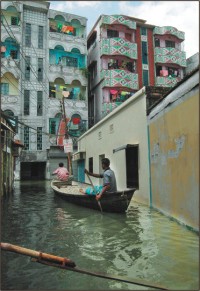
The flood-prone capital runs the risk of edging towards an ecological disaster as most flood-flow zones and water bodies have been filled up over the years in a disturbing sign of reckless urban growth. The filling-up of vast areas in Ashulia, Banashree, Aftabnagar, Meradia, Baunia, Badda, Amin Bazar and Hatirjheel, known as water catchments, increased the hazards of floods that swamped much of the city. The Dhaka Master Plan has clearly marked these areas for flood retention and the Wetland Conservation Act, 2000 bars land development in water bodies. According to the Conservation Act, no-one has the right to develop wetlands, flood-flow zones or catchments. But developers and landowners have illegally occupied and filled up the areas. Aerial photos show how water bodies are narrowing down because of land filling. The government also violates laws. The government plans to develop the city's last remaining water body in Hatirjheel area, spelling a disaster for the city," said Professor Nurul Hasan, chairman of Urban Planning Department at Bangladesh University of Engineering and Technology. Experts said the areas could consume a huge volume of floodwaters and protect many areas from flooding. Moreover, the city had canals, 26 water-reservoirs, hundreds of small and large ponds and marshlands which preserved overflowing water while the canals sent it into different channels. "If we had saved the water bodies, canals and ponds, it could have consumed a third of floodwater," said Selim Bhuiyan, executive engineer of the Flood Forecasting and Warning Centre of the Water Development Board (WDB). A 1992 survey conducted by Flood Action Plan (FAP) under WDB, the area of Dhaka is 118.62 square kilometres, while it has about 736 hectares of water bodies that are only 6 percent of the total area. "The flood-prone and densely populated city requires 25 percent wetland and water bodies for flood control, breathing space and sustainable habitats of flora and fauna," Nurul Hasan said. Last year, a developer engaged more than 100 dredgers for dumping millions of cubic metres of earth in the large wetland, Ashulia, which is under the flood action plan-zone 8A. It planned to create 35,000 plots on 6,000 bighas. Apart from this project, the developer has grabbed more than 73 acres of government land in Ashulia. Rajuk filed a case under clauses 5 and 8 of the Wetland Conservation Act against the developer with Savar Police Station. The developer was accused of illegally occupying wetland in Ashulia and filling it up without an official clearance. The low-lying areas near Rampura towards the Balu river, which is now called Aftabnagar under the flood action plan zone 8B, have also been grabbed. "It has made the drainage system in Dhaka vulnerable. Now it will be a serious barrier to the recession of floodwaters," a WDB official said. The government planned to impose regulations on real estate developers to control the trend of filling up low-lying lands. It was supposed to formulate a separate policy for regulating the unplanned growth of the high-rise buildings. The housing and public works ministry last year initiated the plan, which is now shelved. Housing and Public Works Minister Mirza Abbas said the Wetland Protection Act would be strictly enforced from now on to ensure environmental balance and flooding. The ministry will demarcate 'all flood flow zones' around the city on the basis of the Dhaka Master Plan and aerial photos and make a public announcement soon, giving clear guidelines for real estate development.
|