Dhaka's digital map on cards
Syed Tashfin Chowdhury
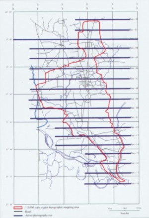
The digital map of Dhaka city is expected to be made available to important departments and agencies and the public within the next two months.Printing of the map is underway at the moment and once completed, it will be a welcome tool in effective planning of the city. The map is likely to make periodical essential activities easier for a number of departments and organizations operating in the private and public sectors. The map would also be used for effective disaster management. The government of Bangladesh and the Japan International Co-operation Agency (JICA) have been working at an urban information management system since January, 2003. From a total of Tk. 23 crore for the entire project, Tk 21.5 crore was provided by the Japanese government for the digital map. "The aim of this project is to prepare a 1:5000 scale digital topographic map of the Dhaka metropolitan city and collect other data for the geographical information system (GIS),"said Matsushiro Horiguchi, Japan's ambassador to Bangladesh during the official announcement of the digital map project earlier this year. The map has been designed with the help of aerial photography and pre-existing topographical maps of the city. Excluding the cantonment area for security reasons, aerial photographs and over 122 topographic map sheets were prepared within the aforementioned scale covering 581 square kilometers. Dhaka City Corporation (DCC) would be the major users of the map which would aid its garbage and waste collection, tax assessment and collection, encroachment control, maintenance of disposal system etc. The tourism department, various intelligence agencies like the National Security Intelligence, Directorate General of Forces Intelligence and Crime Investigation Department, Fire Brigade and Civil Defense, Dhaka Electric Supply Authority (DESA), Bangladesh Road Transport Corporation (BRTC) will also be direct beneficiaries of the map. "We have already printed 20 sheets out of the total 120 sheets of the map," said Shinji Takazawa, a Japanese expert working on the map with the Survey of Bangladesh. "The map would be an essential tool in projects that are being planned at the moment. It would possibly hasten the solution to the waterlogging problems of the city," said Dr. M. Abdul Awal of the Computer Science and Engineering Department of North South University. Dr. Awal is also a consultant in a number of ongoing projects of the Ministry of Science and Information and Communication Technology. The digital map will be made available first on the web page www.iscgm.org/index.htm.
|