Is Kaptai Dam safe in earthquake?
Dr. Aftab Alam Khan
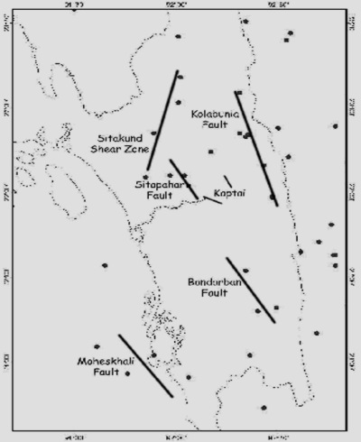
Is Kaptai dam safe in an impending earthquake? The answer is most likely NO. Kaptai dam is the sole hydro-electric installation in the country. The construction of the dam started back in 1954 and completed in 1960. Although the reservoir area covers about 500 sq. km., and the catchment area about 700 sq. km., the peak water level period inundates almost entire catchment area, extending the reservoir area to about 700 sq. km. There are five units having capacity of 242 megawatt electricity generation. However, on and average, it generates about 120 megawatt. Even then, it serves as one of the major power supply plants in Chittagong Division. The pertinent question whether or not, if an earthquake strikes at Kaptai, will the dam sustain its safety? If it does not, what disastrous situation would crop-up all along the downstream of Karnaphuli river from Kaptai to Chittagong? The recent study reveals that number of prominent faults such as Kolabunia fault of Rangamati, Sitapahar fault of Kaptai, and Bandarban fault of Bandarban are quite vulnerable to reactivations in earthquakes. Couple of localised faults are also envisaged in Kaptai area. More alarming is the occurrence of few earthquakes with moderate magnitudes in the recent times with its epicenters falling characteristically in the alignments of the identified faults. If these faults are active, then any moderate earthquake source in the vicinity of Kaptai dam will produce much more peak ground acceleration (PGA) then the inherited PGA characterisation of the geologic materials in the area. A recent study suggests that a maximum PGA of about 0.46g characterises the region along Karnaphuli river alignment. It is also reported that seismic factor 0.1g has been introduced in the construction of Kaptai dam. The Kolabunia earthquake of July 27, 2003 of Rangamati having magnitude 5.6 and depth of focus 10 km., has produced a PGA of 0.1g at a distance about 90 km from the source at Chittagong. This is certainly an indication of vulnerability to produce large PGA maximum of 0.46g if a moderately large earthquake source originates in and around the dam site. The same earthquake has also affected some other civil structures like buildings at Kaptai. It is further observed that the western abutment of the dam is characterised by shale and the hill slope is quite vulnerable to land slides and caving. Although, the dam has been built on to the solid foundation of hard shale, the continuous water seepage would reduce the yield point of shear stress field. This in turn would increase the susceptibility to vibration of the main structure of the dam. Kolabunia fault zone and Sitapahar fault zone have been identified as an active earthquake source element. However, the activities of these fault zones due to impending earthquakes would likely to propagate through insitu fractures and faults to other fault zones. Kolabunia fault being located at much greater distance than Sitapahar fault from Kaptai that could affect Kaptai dam site due to Kolabunia earthquake, the hazard vulnerability risk for Kaptai dam site is much greater in the activation of Sitapahar fault due to same magnitude earthquake as Kolabunia one. Since, Kolabunia fault rupture could affect Kaptai dam site, the movement along Sitapahar fault would certainly affect Kaptai dam site with greater intensity due to same magnitude earthquake as Kolabunia one, if occurs. Sitapahar fault has imposed a visible threat to Kaptai Dam site. Couple of earthquake epicentre locations on to the Sitapahar fault is an active seismic signature of most likely pre-rupture condition with about 30 years return period of 5.9 magnitude earthquake. Since, a 5.9 magnitude earthquake has not occurred in the last 30 years in the Chittagong Hill Tracts, it is feared that this may happen any time. If the dam fails or the abutment collapses then the on rush of water from the reservoir that will inundate and destroy everything downstream of Karnaphuli river is unimaginable. Precaution needs to be taken urgently for the sustainability of Kaptai Dam and also for safeguarding everything along the downstream of Karnaphuli river with respect to habitation and other infra-structural development and redistribution. Micro-earthquake monitoring sensors, at least 3 in number must be installed in the dam site immediately. Much detailed study pertaining to active faults identification, site characterisation and subsurface imaging is highly recommended. Dr. Aftab Alam Khan is Professor, Department of Geology, Dhaka University
|
|