Earthquake risk in Bangladesh: Facing the reality
Dr. Tahmeed M. Al-Hussaini
Adeveloper in Dhaka may claim that his building can withstand a Magnitude 8 (Richter scale) earthquake. This statement can be misleading, because in Dhaka we do not have to design our buildings for such large earthquake. The known earthquake sources that can produce large earthquakes are far away from Dhaka. In fact, earthquake resistant building design at a particular place is based on specified ground shaking (known as intensity) for that location and not on earthquake magnitude. It is important to understand the difference between these basic terms used for describing the strength and effect of earthquakes. Magnitude is a measure of the strength of an earthquake or strain energy released by it, which can be determined from seismographic recordings. There are different scales of they are based on different kinds of measurements and estimation. Earthquake magnitudes are expressed by a number, which is usually in the range of 2 to 10. The different scales usually differ by some small amount, however the variation is larger at large magnitudes. An increase of one unit of magnitude (for example, from 4.6 to 5.6) represents approximately a 30-fold increase in the energy released. Most of the earthquakes occur along plate boundaries of the earth. Damage can be caused by magnitudes greater than about 5, while magnitude greater than about 7 can cause lot of destruction. As examples of big losses during relatively moderate earthquakes, a magnitude 5.8 earthquake in 1960 killed around 12,000 people in Morocco and more recently a magnitude 6.3 earthquake in 1993 killed 30,000 people in India and caused US $ 80 million in losses. Classification of earthquakes based on magnitude and its average annual occurrence in the world is presented in the table below: Description Magnitude Number of events per year Great 8 and higher 1 Major 7 - 7.9 17 Strong 6 - 6.9 134 Moderate 5 - 5.9 1319 Light 4 - 4.9 13,000 (estimated) Minor 3 - 3.9 130,000 (estimated) Very Minor 2 - 2.9 1,300,000 The effect and damage at a place not only depends on the magnitude of the earthquake but also on the distance from the earthquake source and the local soil conditions. The effectmagnitude, of any earthquake diminishes with distance. Intensity is used to represent the effects and damage. The most commonly used intensity scale is the Modified Mercalli Intensity (MMI) Scale, which varies from I (lowest) to XII Recently we have witnessed with horror how destructive and devastating earthquakes can be in the South and South-East Asian region. The most recent 26 December 2004 magnitude 9.0 Sumatra earthquake originating under the sea generated a tsunami in the ocean that destroyed coastal areas in Indonesia, Sri Lanka, India, Thailand, Maldives claiming more than 150,000 liv(most severe). It is therefore necessary to identify first the locations and magnitudes of probable earthquakes and secondly, the damage intensity at a place due to those earthquakes. Earthquake risk at a place is the expected consequences of future seismic events, it therefore depends on the estimated earthquake intensity.es. This tsunami, which was very powerful, also caused damage to Eastern Africa, thousands of(estimated) km away. Although Bangladesh was fortunate to be spared from the devastation this time, the risk of tsunami is there and this needs to be further investigated. The 2001 Bhuj earthquake in India has shown to us that inappropriate construction technology may lead to high casualty levels even for moderate ground shaking. A peak ground acceleration of 0.11g (g is the acceleration due to gravity) caused the collapse/serious damage of numerous mid to high-rise buildings in Ahmedabad, a city around 240 km away from the epicenter of M=7.7 Bhuj earthquake. Note that according to the Bangladesh Building Code, the major cities of Dhaka and Chittagong can be subjected to ground motion reaching higher values (0.15g), while Sylhet, Mymensingh, Rangpur may be subjected to a ground motion of 0.25g. Bangladesh, being located close to the plate margins of Indian and Eurasian plates, is susceptible to earthquakes. The collision of the Indian plate moving northward with the Eurasian plate is the cause of frequent earthquakes in the region comprising Bangladesh and neighbouring India, Nepal and Myanmar. Historically Bangladesh has been affected by five earthquakes of large magnitude (M) greater than 7.0 (Richter scale) during the 61 year period from 1869 to 1930. Among them, the mighty 8+ magnitude 1897 Great Indian earthquake in Shillong, Assam had an epicentral distance of about 230 km from Dhaka. That earthquake caused extensive damages to masonry buildings in many parts of Bangladesh including Dhaka. The 1885 Bengal earthquake (M=7.0, 170 km from Dhaka) and 1918 Srimongal earthquake (M=7.6, 150 km from Dhaka) had their epicentres within Bangladesh, they caused considerable damage locally. Two great (M>8) earthquakes occurred in Bihar in 1934 and in Assam in 1950, but they were too far to cause any damage in Bangladesh. It should be noted that large earthquakes in the region have not been occurring for quite a long time (around 75 years) and hence, the possibility of a major earthquake occurring soon is quite high. According to Prof. Bruce Bolt of University of California at Berkeley, a world renowned seismologist, Bangladesh can be affected by large magnitude earthquakes generated in four tectonic zones, as shown in the following table: The present generation of people in Bangladesh hasn't witnessed any major earthquake. As a result the population has been generally complacent about the risk of earthquakes. During the last seven or eight years, the occurrence and damage caused by some earthquakes (magnitude between 4 and 6) inside the country or near the country's border, has raised the awareness among the general people and the government as well. The damage has been mainly restricted to rural areas or towns near the epicentre, but there has been some instances of damage in urban areas 50 to 100 km away. The writer had the opportunity to visit Chittagong along with his departmental colleague Dr. M.A. Ansary to see the earthquake induced damages following three local earthquakes. Some of the photographs taken by the writer are presented which show the damage caused by these earthquakes. Fig.1 shows the collapse of an under-construction reinforced concrete frame building that killed several people in the port city of Chittagong due to the Nov. 21, 1997 magnitude 6.0 earthquake at the Bangladesh-Myanmar border. This is a typical example of faulty design and construction, collapse occurring at a very low level of shaking, about 100 km from the epicenter of the earthquake. This earthquake also caused some cracks in some buildings and walls in the Chittagong and Bandarban region, and collapse of a potion of an under-construction earthen dam. The July 22, 1999 magnitude 5.1 earthquake with its epicenter very near the island of Moheshkhali, off the coast of the tourist spot of Cox's Bazar, caused extensive damage and collapse of rural mud-walled houses. This earthquake exposed the vulnerability of mud-walled houses, which is quite common in many parts of rural Bangladesh. Cracks and spalling of plaster were observed in some buildings. Concrete column of a cyclone shelter was severely damaged (Fig.2). Soon after the July 27, 2003 magnitude 5.6 Barkal-Rangamati earthquake, the writer visited Rangamati and the badly affected village of Kolabunia, Barkal Upazilla, which is about one and half hour journey by speed boat from Rangamati. Brick masonry buildings of Kolabunia suffered severe damage, brick boundary wall collapsed, and several mud-walled houses were subjected to severe damage to partial collapse of its walls. Large crack developed for a long distance along the river, indicative of soil movement toward the river. Slumping of part of the river bank also occurred at one place. Local people reported emission of bubbles in the river during an aftershock Fig.3 shows a long school building in Rangamati that developed crack in its wall, while Figs.4 to 6 present damage in Kolabunia. In Chittagong city, about 90 km away from the epicenter, the earthquake caused ground settlement and cracks (Fig.7) in the Public Library building and damaged an electric transformer. In addition, minor earthquakes are frequently occurring in the Chittagong area causing a good deal of anxiety among the people there. Dhaka, located in the central region of Bangladesh, could be affected by any of the four earthquake source zones, presented earlier. Another point of major concern is that there are active faults near the city also. This was realized during the 19 Decembr 2001 magnitude 4+ Dhaka earthquake that caused panic among many city residents. The epicenter was very close to Dhaka city. Frightened people in several high rise buildings rushed down the stairs, as they felt considerable shaking in the upper floors. The location of a probable earthquake source so near Dhaka with the probable earthquake magnitude needs to be further investigated. The 1993 Bangladesh National Building Code provides guidelines for earthquake resistant design. The code provides a seismic zoning map which divides Bangladesh into three seismic zones: The north-northeast potion which includes Sylhet, Mymensingh, Bogra, Rangpur falls in the zone "liable to severe damage" (0.25g motion). The middle and southeast portion which includes Dinajpur, Sirajganj, Naogaon, Dhaka, Feni, Chittagong fall in the zone liable to moderate damage" (0.15g motion). The rest of the country in the south-west falls in the zone liable to slight damage" (0.75g motion). All the above discussions were intended to show that we are, indeed, living with the possibility of a major earthquake affecting major cities of Bangladesh. This may occur at any time. Next we need to think about the extent of damage likely for such earthquakes. The urban areas in Bangladesh have developed in a fast pace to accommodate the increasing population resulting in extensive construction of multi-storied buildings. In the absence of legal enforcement of the building code in the country and lack of earthquake awareness in the country, many multistoried buildings have been constructed without proper earthquake consideration. The various factors contributing to the earthquake risk in the urban and rural areas of Bangladesh may be summarized below:
- Absence of earthquake
- Awareness.
- High population density and construction lacking earthquake resistant design
- Absence of legal enforcement of building code and its seismic design provisions
- Poor quality of construction materials and improper construction method
- Economic limitations
- Possibility of fire outbreaks due to rupture of gas pipelines or electric short-circuit during an earthquake and inadequate fire fighting facilities
- Inadequate road width and space between buildings preventing rescue operations and fire-fighting vehicles to reach certain areas.
- Inadequate exit (at the same time) for the occupants of a building during an emergency.
- Lack of facilities (rescue equipment, trained staff, medical personnel, medical facilities) and preparedness for emergency response and recovery operations following an earthquake.
- Lack of earthquake resistant design of life line facilities which include power plants, power stations, bridges, communication control stations, gas and water supply stations etc. The buildings in Dhaka city may be broadly classified into two groups: unreinforced brick masonry (URM) buildings and reinforced concrete frame (RCF) buildings. URM buildings have been observed to behave poorly during earthquakes and they can be more dangerous if they are 4 or more stories high, or built on 5 inch walls, which is not uncommon in Dhaka. RCF construction can also pose equivalent danger if earthquake resistant design provisions are not followed, this has been amply demonstrated in recent earthquakes of Bhuj and Izmit. Economic reasons, lack of quality control in construction and use of poor quality of materials all contribute to the high vulnerability of buildings. A recent building survey, funded by Bangladesh Ministry of Science and Technology research grant, in parts of Sutrapur, Lalbagh and West Dhanmondi reveals concentration of multi-storied URM buildings in the older part of the city. While the percentage of URM buildings in Sutrapur area of the old city was found to be around 65%, the same in the relatively new West Dhanmondi was found to be around 42%. Using Chinese building damage data, the writer has estimated that an intensity VIII earthquake could result in complete or partial collapse of more than 5% and serious damage to around 15% buildings. Intensity VIII corresponds roughly to the ground motion of 0.15g assigned to Dhaka city in the Building Code. This is a preliminary rough estimate, more detailed survey and analysis is necessary for reliable damage and loss estimation. Foundation problems such as earthquake induced ground settlement, liquefaction of loose sandy deposits under water or amplification of ground motion in certain soft soil areas or filled up areas of the city may also substantially increase the damage of buildings. Local soil effects can thus lead to intensity greater than VIII in certain areas of the city causing more damage. Earthquake Disaster Mitigation
Earthquakes cannot be prevented, but its damage can be reduced with suitable measures. While Bangladesh has achieved remarkable success in disaster management for frequently occurring hazards such as cyclone, tornado and floods, it is at an infant stage with regard to earthquakes. We have a long way to go, but at least in the past few years, some encouraging activities have started and are continuing with both individual and institutional efforts. The Government has also stressed the importance for developing a national earthquake management system and has taken steps in this regard. The Department of Civil Engineering, Bangladesh University of Engineering and Technology (BUET) has been involved in earthquake engineering education, research and consultancy services for several years. The Department took the lead role in the preparation of the 1993 national building code which included a new seismic zoning map and earthquake resistant design provisions. The department proposed the formation of a national centre for earthquake engineering at BUET and subsequently got USAID funding for a link project with Virginia Tech, USA. BUET has also been largely involved in the formation of Bangladesh Earthquake Society (BES) in 2002. The first election of the executive body of BES was held in 2003. BES is a multi-disciplinary national professional society dedicated to the cause of preparing the nation to face the threat of possible earthquakes. The organization is expected to create a bridge linking different sections of the people, working together with the government, to achieve a common goal of reducing the earthquake risk. BES, in collaboration with the Ministry of Food, Disaster Management and Relief (MFDMR) and the Disaster Management Bureau (DMB) has already organized several seminars. Earthquake research centers or groups have been formed at several universities, what is needed next is recognition of these groups and collaboration among different groups and individuals. Modern digital seismic instruments, recently installed, are being operated by BUET and Dhaka University, with government and foreign funding. Non-governmental organizations and international organizations are also participating in this effort. BES is publishing a newsletter that gives information on recent activities, earthquake news and articles of interest. The society is also aiming to develop a website which would be an information resource for interested people. BES will also publish relevant manuals or books. For earthquake disaster mitigation, both professional and government solution is needed. Professional solution will be provided by engineers, architects, planners, geologists on technical aspects and social scientists, non-governmental organizations and mass media on social aspects. In the professional solution, civil engineers have the leading role to play, since it is the collapse of civil engineering structures that result in earthquake disasters. For the estimation of probable ground motion, engineers and geologists should work together. Financial institutions, builders and industrialists would be required to support the professional solution. Government solution includes the involvement of the concerned ministries and government or semi-government agencies in implementing the professional solution through policy making and policy enforcement. It needs to be clearly determined who would have regulatory jurisdiction over what. For earthquake disaster mitigation, the following measures should be given top priority:
Increase public awareness about earthquakes through mass media, education (at school), training, earthquake drills, publications etc.
Refined assessment of probable ground motion and identifying local soil effects
Reliable assessment of probable damage to buildings and other structures.
Updating of the building code
Legal enforcement of building code.
Building insurance to promote earthquake resistant construction.
Seismic strengthening of critical structures and facilities.
Developing laboratory and testing facilities for research.
Developing low-cost seismic strengthening techniques so that individual house owners are encouraged to adopt them.
Training of engineers, planners, architects and construction workers.
Automatic safety shutdown system for gas and electricity during a major earthquake.
Developing facilities for post earthquake rescue and recovery.
Urban (including transport) planning of the city to mitigate earthquake effects.
Implementation of national earthquake disaster management plan involving various professionals, officials and volunteers. Earthquake Tips
New Construction - Strengthening Here are some useful tips for new construction and strengthening of existing buildings. Buildings should be designed by a competent engineer following the 1993 Bangladesh National Building Code. Earthquake resistant design involves the use of steel which is a ductile material. It is not economically possible to design a building to resist the extreme earthquake forces without some damage. The building code allows some damage at preferred locations but prevents building collapse and provides safety to life and property. Steel gives the building necessary properties to resist collapse if they are provided at the correct locations of the structure. Structural elements that provide the earthquake resistance include concrete or masonry shear walls, concrete frame, braced frame, rigid floor system and proper connections between them. Proper detailing of the steel reinforcements at critical locations of the building structure is of great significance. ACI (American Concrete Institute) code gives seismic design detailing requirements for reinforced concrete buildings. Other standard building codes such as IBC2000 may also be consulted. Strengthening of non-engineered buildings can be done following the IAEE (International Association for Earthquake Engineering) manual on Guidelines for Earthquake Resistant Non-Engineered Construction. Certain building types are likely to be more susceptible to serious damage or collapse and thus require structural assessment for earthquakes by a competent engineer. Such buildings if not properly designed may need special strengthening measures. Some typical examples are given below:
- Old URM buildings with cracks in walls and roofs on timber beams.
- URM buildings on 5 walls.
- Multi-storied URM buildings with discontinuous lintel.
- Multi-storied RCF building with open parking space on ground floor. Soft-story action or weak column-strong beam action should be prevented.
- Multistoried buildings with large cantilever projections.
- Multi-storied buildings of irregular (unsymmetrical) shape or having setbacks .
- Buildings having mass eccentricity. - Buildings with flat plates.
- Buildings having elevated water tanks or swimming pool on roof top.
- Adjacent multi-storied buildings with little gap, hence possibility of pounding.
- Slender high rise buildings.
- Buildings on soft soil (fill material). When an Earthquake occurs:
During an earthquake, people are injured or killed by falling plaster, collapsing walls, roofs or falling of heavy objects. Collapsing buildings and vibrations can cause short circuits and electric fires. Lighted gas or stoves may also cause fires. This creates panic and confusion. Do's and Don'ts during an Earthquake
If you are indoors:
- Stay calm.
- If you are in the ground floor and you can get out very quickly (5-10 secs), rush outside to an open space away from buildings or electric posts. Usually earthquake shaking lasts less than a minute.
- If you do not have time to go outside, stay at selected places inside your buildings which are relatively stronger against earthquakes such as near strong columns or near closely spaced walls in both directions. Stay away from outer verandah, balconies, cantilever projections, outer walls, doors and windows.
- Get under a table or a sturdy cot so that you are not hurt by falling objects from above.
- Stay away from glass windows, almirahs, showcases, mirrors etc.
- Stay away from falling plaster, bricks or stones.
- Do not rush towards broken or jammed doors or staircase. If you are outdoors:
- Move to nearby open space.
- Keep away from tall chimneys, buildings, balconies and other projections.
- Be careful, hoardings or lamps in the street may fall on you.
Do's and Don'ts following an Earthquake
- Switch off all electrical appliances such as refrigerator, TV.
- Turn off the gas.
- A battery operated radio will help you to get important messages.
- Wear shoes to protect your feet.
- Do not crowd around damaged areas or buildings.
- Keep the streets clear for emergency services.
- Do not waste water.
- Use first aid if someone is hurt. Do not move seriously hurt people. Wait for medical help to arrive.
- If possible, assist children, old and disabled persons and the sick.
- Be prepared for more shocks which always follow a major earthquake. Concluding Remarks
Earthquakes pose a gigantic threat to the economy and well being of this country. While thousands of buildings may collapse in the cities, serious casualties could be in tens of thousands. Seismic risks should be correctly assessed and subsequently mitigated to the extent feasible. A comprehensive and well-coordinated earthquake disaster mitigation plan for the urban as well as rural areas should be developed without further delay and implemented on a priority basis with available resources. Earthquake engineering research centres should be promoted to be focal points for providing expert technical guidance to the country for earthquake disaster mitigation. Such centres can also provide effective education and training of related professionals. Building codes need to be updated and improved. Effective interaction and dialogue between the technical professionals and the government authorities should be ensured. Success of earthquake disaster mitigation efforts will depend on the blending of technical and political solutions into best practices for the reduction of unacceptable risk and sustainable development. Priorities should be established for strengthening the most critical structures and lifeline facilities. The participation of various government, non-government and voluntary organizations, academic institutions, community leadership and media should be encouraged and integrated for maximum benefit. The author is Associate Professor, Department of Civil Engineering, BUET and Editor, Bangladesh Earthquake Societ
|
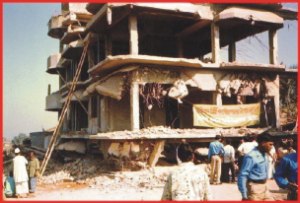
Collapse of under-construction multi-storied building in Chittagong due to Nov.21, 1997 earthquake at Bangladesh-Myanmar border |