Hatirjheel won't be filled up as elevated road planned
Sultana Rahman
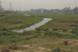
Dhaka City Corporation (DCC) will soon call tenders for the construction of the much talked about elevated road over Hatirjheel area for an east-west road network in the capital.The proposed road stretching from Tongi Diversion Road to Rampura in on the eastern side of the capital. will link the Panthopath-Sonargaon road with Rampura bridge. It is expected to ease the rush of vehicles. The cost of constructing the nearly 100-feet wide elevated road will be around Tk 530.34 crore. "We are now waiting for the Ecnec (Executive Committee for National Economic Council) approval and hopefully it would be placed in the next Ecnec meeting," said MA Momen, chief executive officer of the DCC. According to the project proposal, construction of the road is supposed to start from March this year and it will end in June 2008. Sources in the DCC said that the elevated road will be costlier and narrower but it will save a waterbody as the Hairjheel wetland will not be filed up. "The DCC has prepared a new PCP (project concept paper) for constructing the elevated road following the technical assessment by BUET," Momen said. He further added that they had taken the decision after a detail environmental survey. However, the decision was finally taken after lengthy deliberations and protests from environmentalists against filling up of the city's last remaining waterbody. The Star City also published a series of news items against the government's previous plan of filling up the wetland. The DCC was planning to acquire 200 acres of land on the Rampura-Hatirjheel-Begunbari wetland to launch the controversial development project. "The proposed road is essential to ease the city's ever increasing traffic congestion as Dhaka lacks a east-west road network," Momen said. "There is no straight road from Panthopath to Rampura that forces the commuters to go around the Moghbazar-Malibagh-Mouchack or Mohakhali-Gulshan routes," he added. Urban Planning department of BUET conducted a detailed survey around the entire area considering environmental aspects and suggested constructing the elevated road. The BUET survey said that if the Hatirjheel area was filled up, the city would face an unprecedented waterlogging problem and all roads and localities around the Hatirjheel could become inundated with the slight rainfall. Environmentalists also expressed their deep concern over the project and said the area is naturally designed to retain storm water of an area covering 40 square kilometers. "The recent flood and huge volume of rainfall have prompted the government to save the waterbodies including Hatirjheel and that brought about the shift from the previous plan," said a senior official in the DCC.
|