Urgency of demarcating maritime boundary with Myanmar
Commodore Mohd.Khurshed Alam ndc, psc (Retd)
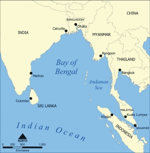
My attention has been drawn to the article "Of Bangladesh-Myanmar sea boundary" published on July 7 in the DS. A very serious issue of great national importance has been dealt with superficially, and an unduly supportive attitude towards the discussion held at the secretary level, has been shown. If mere discussion on a long standing dispute could be enough then we should have been able to solve all our problems with our neighbours. The demarcation of the maritime boundary between Bangladesh and Myanmar should have received the top urgency, both, at the bureaucratic level and in at the political level. Unfortunately, the issue has not received its due priority at any level although from the technical point of view, we are heading for more serious problem with Myanmar in comparison with India as far as maritime boundary is concerned. It can hardly be understood how very important issues of such nature can be left totally unattended by our policy planners in the Ministry of Foreign Affairs. It appears from the published sources that the last time we had official level discussions with Myanmar was about a decade ago and we are now trying to reach a happy reading on the outcome of a courtesy visit. Every time after the visit of some senior bureaucrats to the other capital, such good words like "all outstanding issues will be resolved amicably through negotiations" keep appearing in the newspapers and we feel elated as if the outstanding issues have already been solved or something very different is going to happen towards a solution. But the reality on the ground and the result of 34 years of waiting in hope, dictate otherwise, as the unresolved core maritime issues bear crude testimony to our so called achievements. However, we must accept that there is no alternative to across the table negotiations in settling such issues of maritime boundary. But definitely non-delineation of maritime boundary, either with India or with Myanmar, simply prevents us from drawing any solace that the issues are going to be solved, if not immediately, then in near future and more importantly in our favour. If that be the case, it can be concluded that either we have not taken the initiative to negotiate the maritime boundary at all or even if have negotiated, we will not have done it professionally as the issue did not fit into the scheme of bureaucratic performance, which will bring positional laurels, promotions and better postings. Looking at the coastline of the two countries, we can see that Bangladesh and Myanmar are adjacent countries as per Geneva Convention of the Law of the Sea of 1958 (UNCLOS 1958) and the UNCLOS 1982. The coastline is in the North-South direction and the open sea areas to be delimited lies on the west side. According to known sources, Myanmar and Bangladesh negotiated the delineation of boundary of the Territorial Sea of the two sides in December 1974. The median line was drawn from the terminus of the land boundary in the Naaf river to the midpoint of the closing line between Oyster Island (Myanmar) and St. Martin Island (Bangladesh). This agreement has not been ratified till today. Even though the median line boundary in between St Martin Island, and main land of Myanmar lying on the east of the St Martin Island, might have some justification, but definitely the boundary issue between St Martin and Oyster Island has not been negotiated in line with the Geneva Convention, or with judgments of the ICJ or other tribunals available for consultation at that time. In the UNCLOS of 1958, islands constitute the smallest integral marine geographical feature and that the smallest rock which lies above High Water is geographically, and legally, an island. Their utility to the state and, in particular to the inhabitants of the state, (for it is for the people that the state has been established) creates their value. Size relates to value for surface area is necessary for habitation and for sustenance. Rocks, by these definitions constitute high tide elevations which, due to their small size, would be difficult/ unfit for human habitation. The value of rocks, as a result, would be negligible or nonexistent and they might be conceivably used as sites for navigation. Depending on their geographic relationships to other islands and to adjacent states, they may have full, or partial, effects on the breadth of the Territorial Sea. It is not known under which rules we have negotiated, and drawn, the median line between Oyster Island and St Martin Island. Oyster Island is a rock with no human habitation and St Martin Island, having over 7,000 population, should have received more than half effects/value compared to the Oyster Island. If we had done our homework correctly, we would have the equidistance line shifted more towards Oyster Island, thus getting a better share of the Territorial water. Moreover, the issue of special circumstances, and historic title/economic interests of Bangladesh, should have been the paramount factors for negotiation with Myanmar. We totally lost sight of these two very important issues while preparing our case, most probably not having enough theoretical and practical knowledge about our sea areas. Now there are two other sets of maritime boundary demarcation which have to be settled with Myanmar -- Exclusive Economic Zone (EEZ) of 370 km and Continental Shelf of 650 km long towards the sea. Articles 74 and 83 of UNCLOS 1982 contain no reference to equidistance, which may now be applied only in so far as it leads to an equitable solution. A boundary that might be equitable for EEZ purpose may not be equitable for Continental Shelf purposes because of the different considerations that are relevant to achieving an equitable solution in each case, for example, the location of fish stocks in the case of the EEZ, the geological characteristic the sea bed and the location of sea bed mineral deposits in the case of Continental Shelf. We could have solved the boundary issue (370 km long) based on the UNCLOS 1982, which both countries have ratified. The time is running out for Bangladesh to carry out various seismic, gravity and magnetic surveys in the 650 km long Continental Shelf, based on which we can submit our claim to be approved by the Commission on the Limits of the Continental Shelf of the UN. We now have only 5 years to do all these, and before submitting the claim, we must solve the other boundary issues with Myanmar. Having the equidistance line as the basis for delimitation of the EEZ and CS, as proposed by India and Myanmar, Bangladesh cannot have the declared EEZ, no Continental Shelf and can't avoid being zone locked. In 1993, because of objections of the Myanmar side, the routine hydrographic survey in the vicinity of the Naf river could not be conducted, and Myanmar did not agree to allow blocks for oil exploration in the vicinity of the Rakhine coast. Although our declared straight baselines does not in any way affected the delineation problem with Myanmar at all, still they, in together, with India, have strongly protested our baseline as having no basis of law. How many of us know what Myanmar has done across the Gulf of Martaban while drawing straight baselines? The system violates Article 4 of Geneva Convention, 1958 and Article 7 of UNCLOS, 1982 most flagrantly across the Gulf of Martaban where the world's longest Straight Baseline claim has been established through drawing a 222.3 nautical miles long line and where the Baselines deviate radically from the coast to pick up non fringing islands. Some of its baseline segments deviate 38 degrees from the general direction of the coast. The water, thus improperly internalized, is correspondingly large in comparison with Bangladesh, and Myanmar has excessively gained in her CS/EEZ claim. Rights to the Continental Shelf are inherent and this must be recognized in delimitation, and delimitation by agreement remains the primary rule of international law. Any delimitation, whether agreed or determined by a third party, must result in an equitable solution and there is, in principle, no limit to the factors relevant to the determination of equitableness. In practice, geographical considerations are coming to predominate and the existence of a significant disproportion between the relative maritime areas attaching to the states, and the relative lengths of their coastlines, is likely to be taken as a sign of inequity. However, these will need to be supported by surveys on the exact locations of key features on the coastline in order to gain international recognition, and more importantly to avoid serious disadvantage in bilateral delimitation negotiations. Events in the past do not promise for a good future so often claimed by the officials of the ministry. Looking at the pace our ministry has moved since 1974, it would be futile to appeal to those who hardly stay at the desk of the ministry for more than three years and as a result none could be held responsible for willful neglect of such issues of great national importance so long. We can only sound the national alarm bell, if any, to our political masters to come forward and see that the possession of our rightful sea resources are not wasted by a single day and concrete measures are taken to solve the maritime boundary issue as after 2011, we would be losing thousands of square kilometres of sea areas rich with minerals and fish in the Bay of Bengal.
|
|