Feature
Milestones in Cartography
Compiled by Mahdin Mahboob
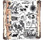 Most of us have been acquainted to World Maps since Grade School. But little did we know the history behind the evolution of Maps over the passage of time. Cartography (the art or technique of making maps or charts) has seen many revolutionary changes since the earliest maps made by the Turkish people in 7,000 BC. Most of us have been acquainted to World Maps since Grade School. But little did we know the history behind the evolution of Maps over the passage of time. Cartography (the art or technique of making maps or charts) has seen many revolutionary changes since the earliest maps made by the Turkish people in 7,000 BC.
Scientific and technological advancements and the discovery of different new places by explorers have all accounted for this issue.
Here is an article from the UKTV History Website on how Maps have evolved to their present state.
Mapping the world has been as essential to man as our desire to build or travel, and this need to understand the way our planet is shaped goes back to prehistoric times. From crude cave paintings filled with religious symbolism to virtual maps electronically designed by computer, the art of mapmaking - or cartography - serves as an ongoing record of humanity's intellectual development.
 Mapping the stars Mapping the stars
The earliest maps were not of Earth but of the heavens. Around 16,000 BC, illustrations of the night sky were discovered on the walls of the Lascaux caves in southern France. Drawings of constellations have also been discovered in the Cueva di El Castillo cave in Spain, dating back to 12,000 BC.
The earliest surviving map of earth was created in the 7,000 BC in Anatolia (modern Turkey). This map is also the first ever plan view - drawn from a bird's eye view - and since then virtually all maps have followed this template.
 The Babylonians: striving for accuracy The Babylonians: striving for accuracy
Archaeologists believe the ancient Babylonians, who lived in what is now Iraq, were the first people to attempt an accurate survey of the land in map form. In 1930 a single clay tablet dating back to at least 2,500 BC was discovered and appeared to depict a river valley between hills on which attempts had clearly been made to accurately measure size and distance between features.
The Babylonians are also credited with creating the earliest surviving map of the world. Created around 600 BC, this map is more symbolic than accurate; it omits references to other neighbouring tribes such as the Persians and Egyptians, even though both were known to the Babylonians.
Fact from fiction
The first significant influences on early mapmaking were not explorers but the works of great Greek writers Homer and Hesiod.
Although neither actually made maps, they both wrote epic poetry describing the world, as the Greeks knew it. Homer's classic poems Iliad and the Odyssey showcased an advanced geographical awareness which was later used by Anaximander and Hecataeus, early mapmakers from the Ionian city of Miletus.
 Miletus: city of Mapmakers Miletus: city of Mapmakers
Miletus, a major trading destination located in Asia Minor, was in prime position to absorb Babylonian influences as well as Greek literature and Mediterranean culture. As a result, the earliest ancient Greeks were ideally positioned to construct the first world maps.
The first of these was Anaximander. Born around 611 BC, he believed Earth was like a stone pillar suspended in space. Many believe him to be the world's first proper mapmaker.
Fifty years later another native son of Miletus called Hecataeus produced an 'improved version' of Anaximander's. Hecataeus's map describes the earth as a circular plate - with Greece at its centre. Distance was measured in 'days of sailing' on the encircling ocean and 'days of marching' on dry land.
Ptolemy: setting the standard
The Greeks later used astronomy and mathematics to prove Earth could be mapped very accurately. Claudius Ptolemy, a Greek living in Roman Egypt during the 2 AD revolutionised maps by introducing lines of longitude and latitude.
It's also fair to say that his eight-book atlas 'Geographia' was a prototype for modern mapping. It included an index of place names and the positioning of north at the top and east to the right still a universal custom.
Islamic mapmaking
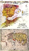
The next major evolutionary stage in the history of mapmaking came from the east. During the Middle Ages, Muslim scholars combined Ptolemy's mathematical methods with knowledge gleaned from explorers and merchants in their travels across the Muslim world, from Spain to India to Africa, and to China and Russia.
In 1,154 AD, a significant Islamic cartographer, Abu Abdullah Ibn Idrisi, published a medieval atlas with the catchy title 'The Recreation for Him Who Wishes to Travel Through the Countries'. In compiling this work, Idrisi actually paid draftsmen to make journeys and map their routes.
Chinese Wisdom
Around the same period the Chinese were making similar advancements in mapmaking. During the Song dynasty (960 to 1,279), maps were Carved in stone depicting the Chinese coastline with remarkable accuracy.
In 1579, Luo Hongxian published the Guang Yutu atlas. It included more than forty maps, a grid system, and a systematic way of representing major landmarks such as mountains, rivers, roads and borders.
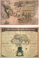
 Age of exploration Age of exploration
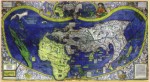
The birth of the Renaissance and the discovery of the Americas by Europeans revived interest in scientific mapping methods. Significant figures of this age of exploration include the monk Nicholas Germanus, who in the fifteenth century added the first new maps to Ptolemy's 'Geographica'. And Spanish explorer Juan de la Cosa's Mappa Mundi of 1500, creator of the first known European cartographic representation of the Americas.
No history of mapmaking would be complete without a mention of Gerardus Mercator, a Flemish cartographer who in 1569 used mathematical formulas in a process now called Mercator's Projection to create a map that first illustrated the world as we are used to seeing it today. In fact, Mercator's projection is still the basis used by US scientists to map satellites.
Cartography in the modern age
During the 1900s, the USA experienced great advancements in cartography, with explorers mapping trails while army engineers surveyed government lands. As a result, two agencies were established to provide detailed, large-scale mapping. In 1884 the Greenwich prime meridian became the international standard reference for cartographers. But it was in the twentieth century that we were truly able to make accurate global maps.
The Computer Age
The role of technology is intrinsically linked with the development of cartography. While the first maps were manually made with brushes, stone and parchment, they varied in quality to the point no two maps charting the same area were completely identical.
Thanks to the invention of the modern compass, printing press, telescope and so on, we can create and reproduce far more accurate maps. Computers have helped to record, store, sort and arrange vast amounts of data for mapmaking. Specific computer hardware devices allow for scanning, processing and spatial analysis and continue to greatly expand our cartographical abilities.
Source : UKTV History Website
|