Feature
An Architect's Dhaka
Mahbubur Rahman
We always have read that 'Dhaka is on the river Buriganga'. Is it really on the river, or the river is on our backyard now?
 Being on a river named Buriganga (meaning the old Ganges) which is connected to all the great rivers of the region was one major reason when Dhaka was selected to be the capital of Subah Bangala in 1608. Buriganga branched off the combined water channel of Dhaleswari and Bangshi at the south of Savar. During the Mughal period, Ichamati-Dhaleswari formed a straighter and wider passage, as Jamuna from north to south was a tiny river, than by the Ganges from Rajmahal (more so from Ghoraghat) to the lower Bengal, which was frequently raided by the Portuguese and Arakanese pirates. The Ganges was gradually shifting away from Rajmahal, the capital till then, which made it difficult for the Mughals to administer the Subah efficiently (suppress rebellion), especially to operate the navy. Being on a river named Buriganga (meaning the old Ganges) which is connected to all the great rivers of the region was one major reason when Dhaka was selected to be the capital of Subah Bangala in 1608. Buriganga branched off the combined water channel of Dhaleswari and Bangshi at the south of Savar. During the Mughal period, Ichamati-Dhaleswari formed a straighter and wider passage, as Jamuna from north to south was a tiny river, than by the Ganges from Rajmahal (more so from Ghoraghat) to the lower Bengal, which was frequently raided by the Portuguese and Arakanese pirates. The Ganges was gradually shifting away from Rajmahal, the capital till then, which made it difficult for the Mughals to administer the Subah efficiently (suppress rebellion), especially to operate the navy.
Another reason for the Mughals wanting to shift deep in the middle of the eastern Bengal was the independent Baro Bhuiyans, who were challenging the Mughal authority, then the mightiest empire in the world, in many parts of the province. Holding over relatively small areas under their jurisdiction, some of them were really popular just because they stood against the mighty Mughals. Not many of these twelve local lords were Bengalis. But their heroics were revered as local rebellion against foreign suppression! We have even streets, students' halls etc. in the name of Isa Khan, who was the most famous of the Baro Bhuiyans. The areas under his command were close to Dhaka, to its east and north, with the capital in Sonargaon for some time, and often shifted around.
Cities have grown (and died) from time immemorial on rivers (and seas). As river courses change, fortunes of cities, including their very existence, change. In this region of the world, particularly within the last three centuries, two great earthquakes were the catalysts of change (in river system), affecting both the great rivers Ganges and Brahmaputra. For thousands of years, great cities were raised and fell along Brahmaputra which are no more there. And the same fate waited for Brahmaputra for sometime of the year it is now difficult to find a trace of the river. The earthquake rather made Jamuna a ferocious river that sealed off the mouths of many mainly east-west flowing rivers. Along with these changes, rulers shifted their residence and court, and more importantly mints.
Mints from where coins would be issued in the name of a particular ruler provided authority to the cities.
There may not have been a fixed city of Sonargaon, but a widely scattered urban settlement in the region. Katrabo (Masumbad) was Isa Khan's capital. The nearby village on the bank of the Shitalakhya, Mahmudabad or the Iqlim Mu'zamabad had administrative centre in Mohzompur north of Sonargaon on the bank of the Brahmaputra. No trace of the city is to be found except a mosque and a tomb. Mahmudabad near Masumabad contains Sultanate period mosques and tombs, and a ruined palace of an Iqlim (governor). Hazrat Jalal Sonargaon was one of the mint towns of early Sultans of Bengal where the representatives of the Sultans of Pandua or Gaur lived. The present villages of Jalalpur and Hazratpur on the northwest of the Panam bridge (may have been built during the Sultans) probably formed Hazrat Jalal Sonargaon.
The valiant Rajput general Raja Mansingh Katchwa was sent to subjugate Isa Khan. Mansingh first stopped in Bhawal and then in 1602 came to Dhaka and fought several battles with Isa Khan. One of these battles took place in as close as Demra at the eastern edge of the present extended conurbation of Dhaka bounded by the river Sitalakhya. While stationing himself at the Afghan (Sher Shahi) Fort (present Central jail) for two years, Mansingh brought his men and accompanied paraphernalia to settle between the old Fort and Dhakeswari Temple to its north-west, and developed Urdibazaar (market of the uniformed, i.e. the soldiers) and old Mughaltoli between the temple and fort, areas that remind us of his presence in Dhaka.
The Afghan Fort, surrounded by mud walls, is also called the Old Fort of Dhaka, which was in fact used as the Subehdar's Palace, government offices, treasury and courts in various periods, before being converted as a jail by the British in 1820. Mirza Nathan, a commander in Islam Khan's army, was sent to Dhaka preceding Khan's arrival to have it repaired to make it suitable as the Subehdar's residence. Though several Subehdars constructed their own palaces in different periods at Lalbag, Posta, Jinjira, Chawkbazaar, none of these survived. Mirza in his book Baharistan I Ghaibi described the Dhaka Fort as one of the largest and strongest in Pre-Mughal Bengal. We will write about its surroundings later.
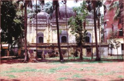
An obscure reminiscence of a structure remotely related to Isa Khan is the mosque behind (south) the Applied Physics building of Dhaka University, on high podiums. A listed building, the mosque is named after his son Musa Khan, and was probably built by his great-grandson Munwar Khan who was a Mughal naval commander winning at Chittagong. In fact Musa Khan too later became ally of the Mughals, leading their army. Musa Khan's grave is there, so is that of Dr. Shahidullah, in the premises of a students hall named after the renowned Dhaka University professor and linguist. The area was once known as Bag e Musa, which later became part of Bag e Badshahi and much later of the Nimtali palace complex.
We have spent many idle noons in the Science Faculty Cafeteria, not an inspiring building, and afternoon in friend's dorm in Shahidullah Hall overlooking ponds dug during the Mughals, never knew that we had such a historic building right in front of us, except that it was old and in ruination. Till now I ask many Dhaka University science teachers and students, they are oblivious of the mosque! They are oblivious of the Nimtali Palace and Deuri, an area taken over by the Anwar Pasha Bhaban and Amor Ekushey Bhaban. They do not know about another Mughal mosque just across the Anwar Pasha Bhaban inside the Anandabazaar Bastee, or the more renowned and listed structures of Haji Shahbaj's mosque and mausoleum at the north-east of Doel Chattar, after crossing the Dhaka gate (wrongly ascribed to Meer Jumla).
The DU Science Faculty premise also had buildings used by the Engineering School, the predecessor of the present Engineering University in Palashi. We have seen a tall chimney in the area from the Secretariat Road on the south connecting Chand Khar Pool with Golap Shah Mazar. Secretariat Road reminds us that the present Dhaka Medical Hospital Building was indeed built to house the Secretariat of the newly created province of East Bengal and Assam. Even the gates of the hospital building are worth preserving as architectural heritage. Chand Khar Pool refers to a small bridge built over a canal connecting Pandu with the Dolai, reminiscence of which were visible in the area till the 1970s.
We first became aware of Haji Shahbaj in our first year of architecture study at BUET when late Mahbubul Ameen who used to teach us drawings suggested to one of our classmates that he draw the Shahbaj Khan mosque in a rendering competition.
(To be continued)
|