Star Law analysis
Legal analysis on oil/gas exploration inside Bangladesh territorial waters
Cdre Md Khurshed Alam ndc, psc BN (Retd)
There had been lot of writings in the newspapers in the past few days about the reported floating of sixth licensing rounds for exploration of 24 marine blocks in the Bay of Bengal by India. According to the sea map published by the Indian Govt., parts of block D-23 overlaps Bangladesh's block 21 in the Bay. Parts of block 22 will also come inside our Speculative Survey Area as demarcated by the Petrobangla. This issue of partial or total overlapping of Bangladeshi blocks declared in 1991with the Indian blocks, brings in a number of long standing and unresolved issues like the BASELINE under Bangladesh's Territorial Water and Maritime Zones Act of 1974, demarcation of maritime boundary between the two countries, and the sovereignty over South Talpatty due to the intransigent attitude of Indian Govt. into the fore. This space would be too little to discuss all these issues in depth but an effort would be made to put things in the right perspectives as far as the exploration in the western sector by the Indian Govt. is concerned.
Bangladesh enacted legislation Territorial Water and Maritime Zones Act of 1974 through the Parliament. Following the promulgation No. LT-1/3/74 of 13th April 1974, Bangladesh declared straight baselines selecting eight imaginary base points following the 10-fathom line or over 60 ft deep water except west of Elephant Point/St. Martins Island as shown in the extracts of charts 859. Bangladesh also claimed 12 nm Territorial water, 18nm Contiguous Zone (24nm allowed under UNCLOS 1982) 200 nm Economic Zone amounting to about 40,000 sq miles of sea area and Continental shelf, (350nm allowed under UNCLOS 1982). While drawing baselines, it is hardly known whether we have taken into consideration the UN Convention on the “Territorial sea and Contiguous Zone”, Convention on the High Seas, on “Fishing and Living Resources of the High Seas” and Convention on the "Continental shelf” which were all in force during that time (in force since 20th March 1966) or followed the historic judgments of Anglo-Norwegian Fisheries case of 1951 or any other customary law.
It appears that by trying to be the first in drawing such unique baselines in South Asia, we have allowed our baby to run before even knowing how to walk and run consequently into serious legal complications and we are really not sure how to get out of this complex problem. From the beginning of the discussion on the Third UN Convention on Law of the Sea (UNCLOS), the Bangladesh proposals seeking to justify the 1974 straight baseline encountered opposition. The main legal objection is that no point of the 10? fathom based baseline is anchored on land. An iso-bath cannot form the basis of the baseline under
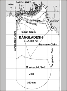 Extract from chart 859 showing conflicting claims of India and Myanmar Extract from chart 859 showing conflicting claims of India and Myanmar |
customary or conventional law. During 8 long years of discussion/negotiation from 1974 till UNCLOS 1982 in the corridors of the UN, our astute diplomacy could not convince our neighbours India and Myanmar or for that matter any country in the world to support our system of drawing baselines other than Vietnam. Finally all our efforts failed to convince the world community participating in the drafting of UNCLOS 1982.The final UNCLOS was approved by the UN General Assembly in 1982 without incorporating our method of drawing straight baselines.
Towards the close of the final negotiating session of UNCLOS, in April, 1982 in New York, Bangladesh addressed a letter to the President of the Conference, seeking to justify our baseline stationed over 10?fathom line. In the process both India and Myanmar took a swipe to our letter and through separate letters to the President of the Conference protested and rejected the Bangladesh baseline claim as unacceptable. However, it is still not known from my knowledge of newspaper deep whether we have at all countered the arguments of the Indian and Myanmar's protests based on the Convention of 1982 or other international customary laws.
Till 1971, 22 exploration wells were drilled in the then East Pakistan, of which eight gas fields were discovered, but all on-shore. The participation of International Oil Companies (IOCs) in our exploration bids was welcomed to help boost and recover country's shattered economy of the post-independence phase. Six (IOC) namely ARCO, Union Oil, Ashland, CSO, BODC and Inanaftaplin entered into Production Sharing Contract (PSC) within nearly entire off-shore region of Bangladesh for “petroleum” exploration in 1974. The decision of leasing out off-shore blocks only was also right in view of the fact that the off-shore exploration is a high tech and costly venture which IOCs were believed to be capable of.
The maritime negotiations between India and Bangladesh commenced when the Government of India in September 1974 protested the proclaimed Bangladesh baseline protruding 21 nm into Indian waters (Infact Indian protest questioned the basic legitimacy of our 1974 baseline and other maritime areas). The protest was in response to award one off shore blocks for oil and gas exploration under production sharing contracts. India claimed that the western most of the six blocks, which had been awarded to Ashland, encroa-ched upon Indian waters. Some of the IOCs left exploration because of the objections raised by India directly to the head offices of such companies about the consequences of oil and gas find as the maritime boundary between two countries has not been delimited.
Within few years of this incident, the issue of South Talpatty came up and when negotiations were continuing between the two govts, India forcibly occupied South Talpatty in May 1981without showing any regard to the agreed negotiations (The issue of South Talpatty has already been discussed by the writer in The Daily Star of 12th May 06). The Govt. of Bangladesh issued a white paper justifying its claims and proposing for joint survey, which the Indian Govt. has not shown any interest to till to-date. India and Myanmar have also been indicating their proposed maritime boundary line with Bangladesh and if they are drawn in the chart, it can be seen that Bangladesh will get zone locked and much of our EEZ/sea area will be inside by Myanmar and India as shown in the chart. We would be zone locked country and would not be able to claim any Continental shelf as per UNCLOS whatsoever.
Although India legislated its Maritime Zones Act as early as 1976, it has not yet published its baseline all along its coast of mainland and around its group of islands which it needs to proclaim and publicise simultaneously as per UNCLOS. India sent two frigates in an apparent move to show open disregard to our gazetted baselines in 1988 and came close to Kutubdia Island and anchored just outside the 12nm Territorial Sea as per UNCLOS. The first one left and another frigate came and anchored exactly in the same place which is about 30nm inside our 1974 baselines and remained there for about 7 days before leaving our water due to diplomatic protests. India ratified the UNCLOS on June 1995, after the formers coming into force in 1994.
The Indian Govt. has also carried out the survey of their total continental shelf and are now in a position to claim another 2 million sq mile. They have been aggressively pursuing their exploration policy and eventually floated their tender in February 24, 2006 which clearly overlaps our block of 21 and our areas of interest. India cannot simply overturn our rights there with a stroke of tender and all her actions till to date must have been taken seriously in the light of international law and we should have stated our position very categorically.
Bangladesh claimed an area covering a "square" whose lateral limits were the meridians of longitude projected from the termini of the land boundaries. The award of offshore blocks was made on the basis of that claim. The basic rationale of our stance was that because of the geomorphologic and geographical peculiarities of our coastline and the concave nature of our coast, the equidistance method of delimitation would result in a cut?off effect introducing distortion in the case of lateral frontier and stressed on the basis of equity. India's unvarying position on the question was that the boundary must be delimited on the rigid application of the equidistance method ignoring the physical features of our coast. The last round of formal talk across the table with India, appears to have taken place in 1980.
In 1989, the entire country was again divided into 23 blocks, of which, 19 blocks including five off-shore blocks were offered to the IOCs for competitive bidding. With the passage of time, 1988 model PSC was followed and out of 23 blocks eight blocks in the first round bidding were given to the IOCs in 1994 and some of the rest most prospective blocks were leased out during 2000-2001 in the second round bidding. During 1991-1996 five blocks and during 1996-2001 six blocks were given to IOCs and PSC was signed. Although re-evaluation of the seismic, drilling and geo-chemical data of the offshore areas of Bangladesh indicates that there is considerable possibility of finding several economic gas accumulations, not much of exploration works on the 5 offshore blocks -- 7.18, 19, 20, 21 -- and 3 other blocks, which are situated partially at sea and in coastal waters -- 15, 16, 17 -- have so far been undertaken by Bangladesh.
In terms of per capita energy used, Bangladesh does not qualify to stand close to many developing nations, not to mention those of the developed nations. Take for example the per capita energy use of Canada, 10493 kgoe, (kilogram oil equivalent), and consumption of Bangladesh is only 196 Kgoe whereas in India/Pakistan it is 446 Kgoe. But the 4/5 of the total population do not have access to commercial energy and only about 29% get electricity. Again per capita electricity consumption is 89 Kilowatt hours (kWh) in Bangladesh as against 379 kWh in India. The households having commercial gas pipeline connection is only 5% of the entire population, only 5 % households use kerosene for lightening, cooking and more than 90% depend on non-commercial biomass for cooking purpose. The country spends about Tk. 4,000 crore annually to import oil and country's annual production and consumption of natural gas is at present about 8.5 million ton oil equivalent which would have a market value of about Tk 8,000 crore.
Thus it is clear that the country is saving about Tk 8,000 crore and if natural gas were not discovered and produced in the country, the nation would have to spend a total of about Tk 12,000 crore annually for imported energy. The country's 60% protein requirement is also being met from the fishery resources. In these circumstances who else need the sea resources more than the ill fated 140 million people of Bangladesh?
The new law of the Sea and other international law have given us the rights to claim sea areas more than the total land area of Bangladesh in the Bay of Bengal with all its living and non-living resources. Indian Govt. has so far not shown any interest to solve these outstanding problems and has consistently denied our rights in the Bay of Bengal. But in the same token our actions have raised more questions than these have answered in the last 32 years. We have taken 19 years to ratify the UNCLOS in 2001, and have not yet started to update our laws of the country in line with the UNCLOS. Our 1974 baselines and base points are not consistent with the UNCLOS 1982, and hence we may have to redraw the baseline. Even if we redraw the baselines, India simply cannot get to the area of our Block 21. But who on God's earth would allow us indefinite time to deal with such important issue which has been neglected so far and precious time has been allowed to pass by and now it seems we are at the mercy of India in the new geopolitical scenario.
Our policy planners have always been successful in guiding the politicians for their postings/promotions but have not taken the same initiative to guide the politicians for bringing a solution to the maritime boundary problems. Our politicians of “Nadi Matrik Bangladesh” probably did not have time to ponder about what is left in the waters and the belly of the Bay of Bengal due to lack of vision, or for a brief which did not tell them the opportune time in the last 32 years.
The author is ex-Chairman, Mongla Port Authority.