Inside
|
Catalysis for a New Dhaka Kazi Khaleed Ashraf visualises the future of Dhaka with Masudul Islam A city can build itself to death, and that is perhaps the most appropriate description of Dhaka's so-called development. Dhaka is basically being built/killed in two ways: by developers and builders whose only concern is maximum economic profit and who could care less about spearheading an environmental and social degradation; and by designated policy-makers whose myopic and miserly visions do not go beyond making regulations and land divisions, and hold no answer to the complexity of the urban landscape. But whatever gets built, little or not so little, has an impact. The fact is despite the perception of our economic limitedness, Dhaka is a city of prodigious and furious building activity, and all that impacts the balance of the ecological, social and economic life-system. The time is ripe for a radical transformation of Dhaka. We know now where the problems are and how acute they are, but the big question is: are we prepared with alternatives? An urban transformation of Dhaka needs to recognize a few key conditions for the city and its regions. The most important is: Dhaka is part of a dynamic hydrological landscape, and for that reason Dhaka should be developed as a hydrological city. Unless we have evolved into superior dry creatures (and it is only the farmers and fishermen in the delta who are destined to stay wet), we will be retaliated by an unforgiving mother nature in multiple ways. The deluge of the 1980s, the lesser floods each year, the climatic changes, the record rainfall of July 28, 2009, are some of nature's way of saying, I shall return. And yet for all that is wrong and all that is calamitous, Dhaka can still be a laboratory for showing a balanced urban dynamic.
A view from above The Google map makes a few things more apparent than other medium for observing and mapping Dhaka: What should be the perimeter of the city? What will happen at that edge? What will happen beyond that edge? What will be the relationship between two sides of the divide? Dhaka cannot grow infinitely in every other direction, swallowing up wetlands and agricultural land with mind-numbing speed and greed, and throwing off balance a precious ecological and hydrological system. If not, then, how will be the population growth and the appetite for urban land solved? That is the challenge. The brilliance for urban designers and planners will be to show that sustaining and enhancing Dhaka's geographic life system can address growth. In the meantime, without a vision, Dhaka hobbles and limps in its urban "growth." I have walked the banks of Buriganga and Turag, that is, wherever it is walkable, sailed down and up the rivers, stood amidst the anarchy in Gabtoli and other points on the western embankment, and I looked and looked but nowhere, absolutely nowhere, have I seen any sign of an intelligent, civic or decent treatment of the water's edge. Nowhere did I find an evidence of a language for developing the riverbanks a plan for a spatially efficient and aesthetically organized system and also something that is economically sustainable. I have seen garbage and effulgence spewed out, shops and shacks tumbling over each other with their back to the river, grown-up men standing and urinating into it, but no sign of a design intelligence. And to think we are a people of land and water, and of rivers and ghats! While we do not have to make a Venice out of our urban rivers (on the other hand, why not!), we don't have to make them into drainage and urination canals either. While some portions of Dhaka's riverbanks are being cleared of encroachment and pollution, the operation should be partnered with an equally vigorous action: what are the sustainable models of urban space, usage and architecture for the riverbanks? I have previously offered some sketch ideas for the Sadarghat area. I wanted to point out that some critical sites in the city should be selected for urban design intervention for a couple of reasons: to treat the projected development as an urban catalyst, an acupuncture in the miasma-ridden body of the city; and, to develop a clear and distinctive language for a designed development at the edge. Taking on Tongi
Dhaka has not seen projects that can be described as projects prone to catalysis, that is, sites because of their critical location and multiple vocations harbor the capacity to induce far-reaching and multi-level impact on the city. The recent initiative with Hatirjheel bears the promise of being such a "catalytical" project. The administration involved is to be thanked for taking that on as an opportunity to create designed urban spaces, re-organize infrastructure and reconstruct some of the old wetland in the heart of the city. There are many such opportunities in this city of a reckless future. Take Tongi for example, a curious urban concatenation that one would be hard-pressed to call even a "township." Tongi is divided blatantly along the Dhaka-Gazipur Road. On the western side, there is a somewhat disciplined layout of industrial lots, while on the right side is a wild melee of dwellings, factories, industries, shops, markets, vestigial lands that do not come together to forget an efficacious urban fabric or community. Tongi is a good example of how old agricultural lands have tumbled pell-mell into ad-hoc land divisions and usages without an urban identity and coherence. I describe that as being "urbanised without urbanism": that is, the area is simply teeming with human settlement and a marginal infrastructure. Tongi is but one example of much of the regions of Dhaka city: settled, populated, urbanised but without urbanism. All perhaps may not be hopeless. There still remains a great opportunity for converting Tongi into a highly planned, effective and disciplined urban fabric, and perhaps even globally positioned township. I describe such a development as an urban "acupuncture" as it not only affects, positively, the immediate area but also offers multiple dividends for the rest of the city. Such a development is also an opportunity to plan the "outer ring" of Dhaka city that can then both control and give creative impetus to developments in those rings. There is no reason to think the northern development of Dhaka city will end at Uttara and Tongi will remain as a place "over there." The whole of Tongi area can come under a special planning action that can systematically convert it into a denser, planned and truly urban place that is socially and economically richer. Reorganization of a vast part of Tongi is easily possible that might create new garments factory district with demarcated areas for factories, offices and warehouses, and housing and amenities for the workers with efficient transportation network. Similarly, an IT district may also be conceived where people can be trained in the new electronic media and outsourcing stations may be set up. Only then, Tongi may be reincarnated into a modern industrious town, and a more proper gateway to Dhaka.
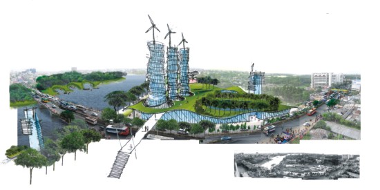
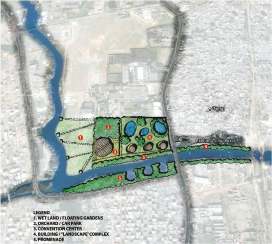
At the bend of the Turag What about a new type of building altogether? A new super "building" form that wraps around existing ponds and trees, and itself appears as a landscape with grass, bamboo groves and vegetation on its extensive, undulating roof? It is basically a "landscapey" building where the roof becomes a large public plaza or elevated garden from where people can go for recreation and get a vantage point to enjoy the riverviews. The configuration of the building, with the large perforations that bring in light and air and provide a semi-forested environment, blurs the conventional experience of building and exterior space. The building complex also performs as a kind of gateway for the city. The edge of the river will be a long promenade that connects from the bend of Turag in Asulia in the west to the railway crossings in the east. The promenade goes past Tongi Bazaar providing a needed "breathing space" from the melee of the bazaar and also replaces illegal occupancies that choke up the edge. The promenade in some cases can become wider to be designated public spaces. The "landscapey" building will house mixed-use activities from shops and business houses to spaces for cultural activities. The side facing the river may contain art galleries, restaurants and cafes creating a small art district. The three energy-conscious, energy-generating towers emerging from the landscape building may be positioned for office rentals and global businesses such as IT. One of the towers can be a five star hotel. A new convention center and complex is visualised at the bend of the Turag as a way of bookending development at that area and to provide a visual icon that may be seen from the Asulia highway. With the increasing intensity of various gatherings in Dhaka, the city very well needs one or two more convention or conference center. With the adjoining hotel tower and civic facilities in the super-building (and proximity to the airport), the conference center can be promoted in the Asian region for various meetings, conferences or conventions.
The area designated for Ijtema can be better organised for hosting such an important and vast congregation. While the Ijtema is only for a few days, at other time of the year, the area can be used for public recreation such as a park, industrial fair or site for portable gardens. The area can host a large-scale flower market (and thus employment opportunities) where flowers can be cultivated on floats on wheels, that can be moved away during the Ijtema (as a procession through the city), or even literally floated down the Turag in a colorful celebration of both rivers and flowers as a new ritual for the city. Kazi Khaleed Ashraf is an architect, urbanist and author, and teaches at the University of Hawaii in Honolulu. Masudul Islam produced the images for the article. He is an architect with Salauddin Ahmed at Atelier Robin in Dhaka. |