Inside
|
Bangladesh-India: Conflicts over land and maritime boundaries
SYEED AHAMED revisits the lessons learnt from two exceptional boundary disputes to highlight some policy priorities.
The Indian Prime Minister Manmohan Singh's official visit to Dhaka is expected to address some of the long-standing multi-faceted disputes between Bangladesh and India. The dispute over land and maritime boundaries remains one such unsettled issue that the officials of both the countries are trying hard to work out during this visit. More than six decades after the partition and four decades after the independence of Bangladesh, the two countries have finally signed the border maps to officially recognise their international boundary and end a lingering dispute over the issue.
The countries even intend to address the much more complicated issues regarding enclave-exchange and maritime boundaries. This is not the first time the two countries came close to solving such problems, but regrettably, at least twice it was India that failed to implement bilateral agreements on border issues.
As the two prime ministers address these issues, this article revisits the lessons learnt from two exceptional boundary disputes to highlight some policy priorities.
Disputes over enclaves/exclaves
An enclave is a territory within or surrounded by another territory. When an enclave belongs to another sovereign country, it's called an exclave of that sovereign country. In this part of the world, we call it a 'chitmahal'. These are the scattered pieces of lands -- some of them belong to Bangladesh but are within Indian territory; and others belong to India, but are inside Bangladesh's territorial boundaries.
Some of the boundaries of these enclaves are very complicated (see Figure 1). There are counter-enclaves which belong to Bangladesh, but are within an Indian territory that is also surrounded by Bangladesh, and vice versa. Interestingly, there is also a counter-counter-enclave, a piece of land, which belongs to India that is within Bangladesh within India within Bangladesh.
Confusing, right?
Figure 1: Enclaves and Counter-enclaves within Bangladesh and India
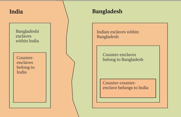
As Figure 1 illustrates, part of Indian and Bangladeshi land are not only inside each-other's territory, there are small pockets within those adversely situated lands that belong to other country.
There are alternative hypotheses that tried to explain the origin of these sheer bizarreness that otherwise defy any reasonable explanation.
Whyte (2002) offered a detailed history that tells how these enclaves originated during the pre-colonial era when Mughal expansion faced pockets of resistance by the chieftains of Cooch Bihar and resulted in enclaves (that belonged to Cooch Bihar) within Mughal controlled Rangpur region. Alternative hypothesis suggests that the Maharaja of Cooch Bihar and Foujdar of Rangpur used to gamble or play chess wagering villages on the win. As they won and lost villages to each other, many enclaves emerged in their territories. Another unlikely hypothesis suggests that Cyril Radcliffe -- who drew the India-Pakistan border in 1947 -- was in a hurry (and drunk too, in some telling of the story) and he accidentally dropped some ink dots on the map, creating these enclaves.
However, there is no denying the fact that Radcliffe had no knowledge in geographical map setting and had only few days to complete the demarcation process on the basis of the now-discredited two-nation doctrine. During the British rule, Cooch Bihar remained as a Princely state. An exchange of these enclaves, initiated by the British rulers during the 1930s, was abandoned when the residents of the enclaves wished to retain their status quo. During partition, Radcliffe ultimately drew the boundaries without exchanging these enclaves between Cooch Bihar and Rangpur. The demarcation decision was kept as a top secret until two days after the separation. When Cooch Bihar and Rangpur became part of India and East Pakistan respectively, the enclaves became a permanent problem.
Both Pakistan and India tried to exchange the enclaves and signed a treaty in 1958. However, India never implemented the treaty. After liberation, Bangladesh also signed a treaty with India in 1974, but India never ratified this treaty either. Furthermore, Bangladesh offered its Berubari exclave within India in exchange for a narrow tin-bigha corridor to get connected with its own exclave of Dahogram-Angorpota. Instead of handing over the corridor, India came up with all sorts of alternative approaches, including hourly opening of the corridor or even building a flyover to the exclave!
And yet, Mr Singh had to hypothesise Bangladesh's so-called anti-India sentiment with some pro-Pakistan conspiracy theories (Sobhan, 2011)!
Now that the Indian Prime Minister's visit is due, both the countries are working hard to solve the enclave issue once and for all. The Joint Boundary Working Group (JBWG) conducted series of meetings and carried out surveys to exchange the exclaves. However, based on our historical experience with these enclaves, we need to address some technical dilemmas first.
The first and foremost issue is the access to information. Remember, it is this absolute secrecy of Radcliff's partition process that prevented an early solution in the first place. The governments should publish the results of the survey conducted by the JBWG, before signing the treaty. It has been reported that there are 111 Indian exclaves within Bangladesh, while 51 Bangladesh's exclaves are in India (Daily Star, 2011). However, previous reports suggested that there are 106 Indian enclaves occupying some 20,000 acres within Bangladesh, while 92 Bangladeshi enclaves occupying about 12,000 acres within Indian territory (Times of India, 2011). It is to be mentioned that, some Bangladeshi enclaves are within Bangladeshi territory and vice-versa. But however these enclaves are defined and exchanged, people also have the right to know as to how these enclaves are being exchanged.
The second concern is to ensure that India does not pull back after signing the treaty, as it did twice in the past. India probably assumes that they are in a weaker position on this bargain as Bangladesh will gain some land if all the enclaves are merged into their respective host countries. This is one reason that's presumably stopped India from solving the issue. As the Indian media reported, India will end up losing some 8,000 acres after both the countries exchange each other's enclaves. However, India fails to understand that most of these Indian exclaves are inaccessible by them and will remain within Bangladesh's sovereign territory. Moreover, Bangladesh has already handed over a very significant piece of its exclaves (Berubari), though in return India failed to hand over a tiny corridor to Bangladesh.
Keeping in mind India's previous failures in implementing bilateral treaties, Bangladesh should insist on legally binding treaties and if necessary, special clauses in the treaty whereby both sides will have to
hand over the promised exclaves to enjoy their sovereignty over the enclaves they receive. Besides, this time it's only fair that Bangladesh waits for India to ratify the treaty first. Also, to legally strengthen the deal, the enclaves should be treated as 'exchanged' not 'handed over'.
Finally, given the fact that these enclaves are not individual sovereign entities, rather a part of a larger sovereign state; can the international law accept the decisions taken by the states over their respective enclaves? Otherwise, if people of the enclaves are allowed to have their say in the re-demarcation process, what will happen if they want to maintain their status quo? Nonetheless, the residents should be allowed to remain where they are or migrate to other country. Any chance of forced migration by the opportunists of both sides must be prevented at any cost.
Disputes over maritime boundaries
The disputes over the territorial boundaries amongst Bangladesh-India-Myanmar are based on two fundamental disagreements among the three countries on the methods of delineating these maritime boundaries.
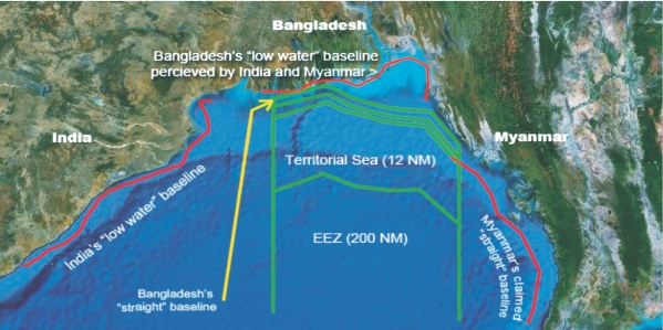
According to international law, the first 12 nautical miles from the sea baseline is called the 'territorial sea' where a country has its absolute sovereignty. The next 200 nautical miles are called the Exclusive Economic Zone (EEZ) where a country has special rights over the exploration and use of marine resources.
But, from which baseline and to which direction do they measure these distances? Well, Bangladesh, India and Myanmar beg to differ on that question.
India and Myanmar prefer a 'low water' sea baseline -- that closely follows the curves of the vertical coastlines for their maritime boundaries (see Figure 2). But Bangladesh prefers a 'straight baseline' anchored in different coastal landmarks (e.g. islands, low-water points, etc.) since it has a very uneven coastline, and it's difficult to measure 'low-water sea baseline' where so many rivers unite with the sea. India and Myanmar, however, insist that Bangladesh should not follow a straight baseline
Figure 2: Territorial Sea Baselines
 Source: Nahar, 2009
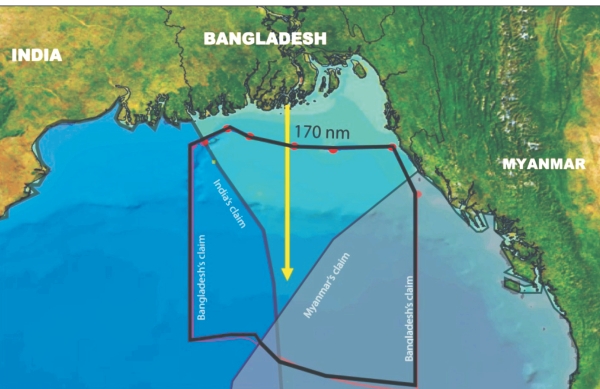
On the other hand, India and Myanmar have delineated their maritime boundaries based on 'equal distance' from their respective coastlines at West and East shore of the Bay of Bengal. Given the triangular shape of the Bay of Bengal, such demarcation not only deprives Bangladesh from sea resources, it also makes it a 'zone-locked' country (see Figure 3). Following international examples, Bangladesh proposed 'equity' method to delineate the boundaries for just and equitable shares of the deep-sea territory.
Figure 3: Zone-locked Bangladesh
 Source: Nahar, 2009
Myanmar has further complicated the conflict by re-demarcating its maritime boundary using 'straight' baseline, though its geological nature does not permit such delineation.
Without solving the boundary dispute, India and Myanmar then announced their offshore blocks for exploration and extraction of oil and gas in the deep sea. Their deep-sea blocks overlapped with Bangladesh's deep-sea territory. In 2008, Bangladesh even had to show up its naval force to stop Myanmar from exploring natural resources inside Bangladesh's deep sea block. Meanwhile, India also began exploration of gas close to the disputed territory. In response, Bangladesh hurriedly appointed ConocoPhillips to explore gas in that disputed block. Both the countries however agreed not to carry out exploration in the disputed part of the overlapping blocks. But the dispute continued.
In the end, Bangladesh had to request an UN intervention. Bangladesh has already lodged a complaint against Myanmar at the UN, and in response, the International Tribunal for the Law of the Sea (ITLOS) has initiated the arbitration process.
Meanwhile, it was assumed that Bangladesh will take the Indian case to ITLOS as well. Hence, no bilateral agreement was pursued during the Bangladeshi Prime Minister's visit to India in 2010.
In a similar case in 1969, the International Court of Justice (ICJ) rejected Denmark and Netherland's claims for equidistance territory, considering Germany's special location. Also, after the 1951 Anglo-Norwegian Fisheries Case, demarcation of straight baseline for countries with especial coastlines has become a lawful practice. While Bangladesh awaits a legal verdict on the matter by the first quarter of 2012, experts suggested that Bangladesh has a better chance of winning the case against Myanmar.
At this point, Bangladesh should not hurry to reach any unfavourable agreement with India. When the arbitration was initiated, Myanmar suddenly became enthusiastic about carrying on bilateral talks with Bangladesh. Myanmar has already toned down its previously-inflexible position after 36 years and has finally admitted to consider a combination of equity and equal distance approach.
At this moment, India might insist that Bangladesh solves the maritime boundary dispute in bilateral talks, instead of seeking ITLOS intervention. If that happens, Bangladesh should use Myanmar's changing position as leverage in its negotiation with India. Unless India agrees to some legally binding decisions on equity and straight baseline demarcations, Bangladesh should keep the ITLOS option open.
***
If Bangladesh and India are to address the long list of disputed issues in this meeting, solving the boundary dispute should be a priority. While Robert Frost is right in arguing that -- 'something there is that doesn't love a wall', in case of sovereign states, 'good fences do make good neighbours'.
Nahar, S. 2009. “UN to arbitrate maritime boundary disputes among Bangladesh, India and Myanmar: The last but not the least alternative”. Paper submitted to the Department of International Relations, La Trobe University. Melbourne: La Trobe University.
Sobhan, Z. 2011. What does 'anti-Indian' mean?. The Sunday Guardian. http://www.sunday-guardian.com/analysis/what-does-anti-indian-mean
The Daily Star. 2011 (20 July) Census in all enclaves done. URL: http://bit.ly/mSuBUF
Times of India. 2011 (29 July). Border issue to top Chidambaram's Dhaka agenda. URL: http://bit.ly/qWYOdQ
Whyte, B. R. 2002. Waiting for the Esquimo: An historical and documentary study of the Cooch Behar enclaves of India and Bangladesh. Research Paper 8. Melbourne: School of Anthropology, Geography and Environmental Studies. University of Melbourne.
Syeed Ahamed is the CEO of Institute of Informatics and Development and a member of Drishtipat Writers' Collective. He can be reached at ahamed.syeed@gmail.com.